


GPS+GLONASS |

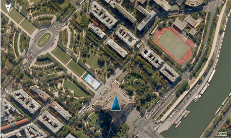
BIRDSEYE SATELLITE IMAGERY |

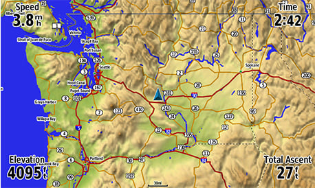
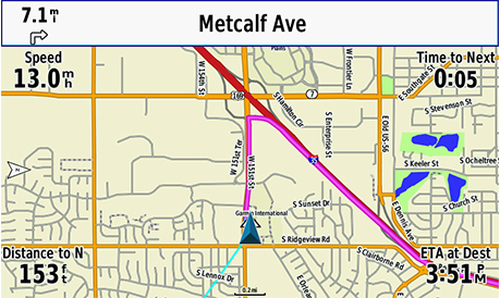
ADVANCED MAPPING |
ACTIVE WEATHER |

SMART NOTIFICATIONS |
Price: ₹76,427/-, ₹53,499/- (30% OFF)
Feature
All-terrain GPS Navigator
- Internal antenna with GPS and GLONASS satellite reception for tracking in more challenging environments than GPS alone; for better reception in vehicle interiors add an external antenna (sold separately) to the built-in MCX connector
- Built-in worldwide basemap and free 1-year BirdsEye Satellite Imagery subscription
- Supports Garmin TOPO maps, Garmin HuntView™ maps, BlueChart® g2 HD marine charts and more
- Supports Active Weather forecasts and animated weather tracking
- Pairs with your compatible smartphone¹ for automatic uploads, smart notifications and more

The Mapping You Want
Almost anywhere you want to go, GPSMAP 276Cx has a compatible map to take you there. It comes preloaded with worldwide basemap and includes a free 1-year BirdsEye Satellite Imagery subscription. It also supports a variety of other mapping options such as Garmin TOPO maps, Garmin HuntView™ maps, BlueChart® g2 HD marine charts, turn-by-turn directions on City Navigator® NT, Garmin Custom Maps, raster maps and vector maps.
The Connected Navigator
In addition to GPS and GLONASS reception, GPSMAP 276Cx is ANT+® compatible for the integration of external sensors like the tempe™ ambient temperature sensor. You can even connect it to Wi-Fi® for over-the-air updates and Garmin Connect™ database syncs. Pair with your compatible mobile device¹ for additional features like LiveTrack and smart notifications¹.
Tough and Ready
GPSMAP 276Cx was designed for your rugged lifestyle. You’ll navigate with confidence by seeing clearly on the large 5-inch sunlight-readable screen. The navigator’s flexible mounting lets you keep the device exactly where you need it. Operate GPSMAP 276Cx with its reliable push-button controls that resist dirt, dust and grit, and best of all –– keep all your maps on hand with 8 GB of internal memory, expandable by a microSD™ card (sold separately).

More Power Options
Get peace of mind knowing that the GPSMAP 276Cx GPS navigator is going to be ready when you need it, now that there are more ways to power your device. It features in-unit charging with an included lithium-ion battery pack and even has the ability to use standard AA batteries.
Weather is not available in all areas.
Wi-Fi® is a registered trademark of the Wi-Fi Alliance.
Specifications
General
| Physical dimensions | 7.5" x 3.7" x 1.7" (191.5 x 94.5 x 44.0 cm) |
| Weight | 15.9 oz (450 g) with included rechargeable pack; 14.6 oz (415 g) with AA batteries (not included) |
| Water rating | IPX7 |
| Battery type | rechargeable lithium-ion (included) or 3 AA batteries (not included); NiMH or Lithium recommended |
| Display type | bright, sunlight readable WVGA display |
| Display size | 5.0" (127.0 mm) diagonal |
| Display resolution | 800 x 480 pixels |
| Battery life | up to 16 hours (lithium-ion); up to 8 hours (AA batteries) |
| Memory/history | 8 GB (6 GB available to use) |
| High-sensitivity receiver | YES |
| Interface | high-speed USB and NMEA 0183 compatible |
Maps & Memory
| Basemap | YES |
| Ability to add maps | YES |
| Accepts data cards | microSD™ card (not included) |
| Custom POIs (ability to add additional points of interest) | YES |
| Waypoints/favorites/locations | 10,000 |
| Routes | 250 |
| Track log | 20,000 points, 250 saved tracks |
Sensors
| Barometric altimeter | YES |
| Compass | Yes (tilt-compensated 3-axis) |
Outdoor Recreation Features
| Automatic routing (turn by turn routing on roads) | Yes (with optional mapping for detailed roads) |
| Custom maps compatible | YES |
| Hunt/fish calendar | YES |
| Sun and moon information | YES |
| Camera | no |
Garmin Connect™
| Garmin Connect™ compatible (online community where you analyze, categorize and share data) | YES |
Additional
| Additional |
|
Contents in the box
GPSMAP 276Cx , 5.90 Software Update
Steps to update the software:
- Download and install Garmin Express to your computer.
- Connect your device to your computer.
- Launch Garmin Express and select "Add a Device", and follow the onscreen instructions.
- Garmin Express will list items that need to be updated, simply click "Install/Install All" and follow the onscreen instructions.
- Wait until the program displays that all files are up to date.
Note:
- The installer may overwrite data within the device. Please backup any important files beforehand.
System Requirements:
Windows
- Windows Vista SP2 or later, Microsoft .NET 4.5 (included)
- 1024x768 resolution, USB port and 1 GB RAM
- High speed internet (do not use in conjunction with dial-up, mobile, or satellite connection)
- Up to 13 GB of storage
Mac
- OSX 10.8 or later
- 1440x900 resolution, USB port and 1 GB RAM
- High speed internet (do not use in conjunction with dial-up, mobile, or satellite connection)
- Up to 13 GB of storage
Latest Version2021-12-03。
Version : 5.90 New!
- Fixed issue drawing color indicators in the track list
- Fixed map heading responsiveness at low speeds
sdf


0 Reviews:
Post a Comment